
1941
La Compagnie d’Électricité Loire et Centre débute les études préliminaires du complexe de Montpezat
1947
Après la guerre, le projet s’affine et se concrétise afin de répondre aux besoins énergétiques de la France en pleine reconstruction
18 novembre 1948
Le projet est adopté à l’Assemblée Nationale malgré de nombreuses oppositions. Les populations Altiligérienne et du plateau Ardéchois ne souhaitaient pas voir partir leur eau dans le bassin hydrographique de l’Ardèche.
21 mars 1949
Loi n°49-399 : Le projet est décrété d’utilité publique. Le Parlement autorise le transfert d’eau de la Loire vers l’Ardèche (interdit jusqu’alors). EDF obtient la concession de l’ouvrage.
1947-1953
Travaux de percement du lac d’Issarlès et des galeries d’amenée
1951- 1954
Construction des 3 barrages la Grange sur la Veyradère, Lapalisse sur la Loire et du Gage sur le Gage
1954
Fin des travaux, mise en eau des barrages et mise en service de l’usine
1965-1966
Afin de garantir la sûreté de l’ouvrage, le barrage du Gage a été renforcé par la construction d’un nouveau barrage (Gage II) en amont direct du premier.
1984
- La loi sur la pêche fixe pour tous les aménagements hydroélectriques déjà en service le débit réservé minimum à laisser en rivière à l’aval d’une prise d’eau au 1/40è du module. Le module de la Loire en tête de bassin est de 8.2 m³/s.
- 9 novembre 1984 : Signature du contrat de rivière « Ardèche Claire » entre le Ministère de l’Environnement, la Région Rhône-Alpes, le Conseil Général de l’Ardèche et le Syndicat Intercommunal de la Vallée de l’Ardèche (SIVA) dont les objectifs sont la reconquête de la qualité des eaux, la mise en valeur du milieu naturel, le développement harmonieux des activités de loisirs lié à la rivière. Pour permettre le soutien d’étiage et l’alimentation en eau potable de la Basse Ardèche, la construction du barrage de Pont de Veyrières est planifié ainsi que la construction d’un réseau de 50 km de canalisations et interconnexion des réseaux existants à partir d’une prise d’eau dans le barrage.
- Hiver 1984-1985 : Construction du barrage de la Veyrière en Ardèche. Il a pour fonction démodulation des lâchers à l’aval de l’usine de Montpezat et le soutien des débits durant la période estivale, permettant l’obtention des objectifs de qualité fixés pour la rivière et la valorisation du milieu.
1994
le Syndicat Intercommunal de la Vallée de l’Ardèche (SIVA) met en service l’usine d’alimentation en eau potable de Pont de Veyrières qui désert 81 communes.
Novembre 2005
Installation de la Commission Inter-SAGE Loire-Amont /Ardèche afin d’assurer la cohérence, le suivi et les échanges entre les deux démarches et de garantir une concertation partagée entre les deux réflexions.
2013-2018
Construction d’un évacuateur de crue sur le barrage du Gage permettant de faire passer une crue millenale (675m3/s).
2014
Augmentation du débit garanti au Pont-de-la-Borie : passage du 40ème du module au 20ême
2019
Le barrage de Lapalisse est renforcé pour surmonter une crue de type millénal
2023
SOS Loire Vivante organise une Marche citoyenne pour un partage d’Eau équitable entre la Loire et l’Ardèche ! du 1er au 9 juillet 2023
2024-2025
Grâce aux actions de la campagne menée par SOS Loire Vivante – ERN depuis 2021. La commission Intersage Loire Ardèche s’est enfin réunie. Un GT intersage restreint constitué d’acteurs du bassin de la Loire et de l’Ardèche, avec SOS Loire Vivante – ERN et animé par le Préfet de la Haute Loire a été mis en place en 2024. Il vise à poser les bases de la future concession et partager les diverses problématiques autour de la gestion de l’ouvrage, Le GT a livré ses recommandations en 2026 à l’interSAGE Loire Amont Ardèche.
2026
SOS Loire Vivante organise une Marche citoyenne et signe un manifeste pour la protection de la Haute Vallée de la Loire ! du 3er au 5 juillet 2026
2028
Fin de la concession attribuée à EDF pour l’exploitation
How It Works
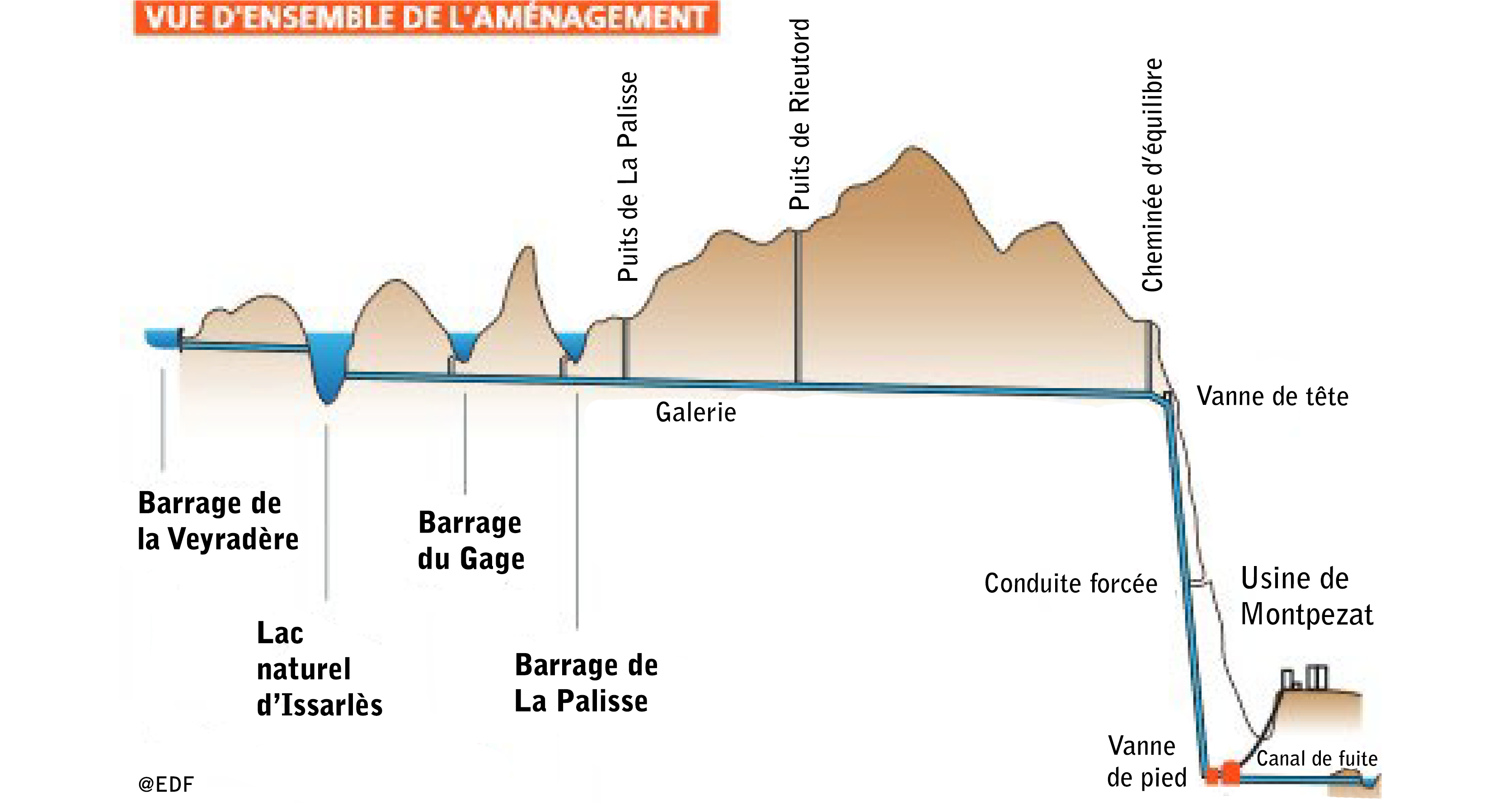
The Montpezat hydroelectric complex, a remarkable achievement of post war engineering, was designed to respond to the energy shortages of the time. The power plant is located 120 metres underground beneath the village of Montpezat sous Bauzon.
The guiding principle behind this development was to divert large volumes of water from the Loire and its tributaries toward the Ardèche downstream, creating a significant drop in elevation that could be used to generate electricity during peak periods of high demand. At the same time, the installation helps secure the operation of the Cruas nuclear power plant on the Rhône. Beginning in the 1990s, a new function was added: regulating the low-water flow of the Ardèche, and more recently, that of the Loire.
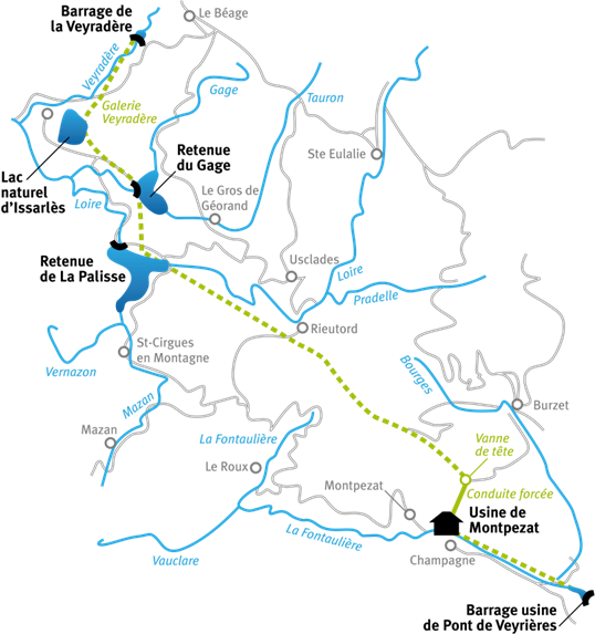
The Montpezat complex includes three structures on the Loire side: the Grange intake on the Veyradeyre, the Gage dam, and the Lapalisse dam, as well as the natural Lake Issarlès. All of these sites are located only a few kilometres from the source of the Loire and are all interconnected. Together, they form a usable water reserve of 40.8 million cubic metres.
To link the reservoirs, the lake and the power plant, a gallery was excavated beneath the mountain. On the Loire side, water can circulate in both directions through this gallery, allowing multiple operating configurations; whether filling the reservoirs or sending water to generate electricity.
With a total length of 25 kilometres, the gallery crosses the watershed between the Mediterranean and the Atlantic and ends in a 1.4 kilometre pressure tunnel that delivers the water to the underground Montpezat power station after a drop of 636 metres. Once it has passed through the turbines, the water flows into the Fontaulière and then to the Pont de Veyrières dam, where it is used again for hydropower production.
Three-step management :
– March 7 through June 14: This is the filling period : water is collected and stored, and normally no electricity is produced during this period.
– From June 15 to September 15: This is the period during which the reservoirs are used for low-flow support (mandatory): As a general rule, on the Ardèche side, this begins almost immediately in mid-June (8.4 Mio m³ on average), and on the Loire side, it begins in late July/early August (with successive increases from 0.5 Mio m³ between 1988 and 2014 to 2 Mio m³ since 2022). The total volume available for low-flow support is fixed at around 12 Mio m³. However,this does not take into account the usable volume of Lake Issarlès, which must maintain its “natural” level until September 15 (for tourism purposes).
– From September 16 to March 6: this is the run-of-river period during which peak electricity is generated for a few hours each day. Reservoir volumes are utilized, as is all the fall and winter precipitation flowing into the structures, with a required minimum flow of 0.4 m³/s for the Loire River.
Figures for 2023
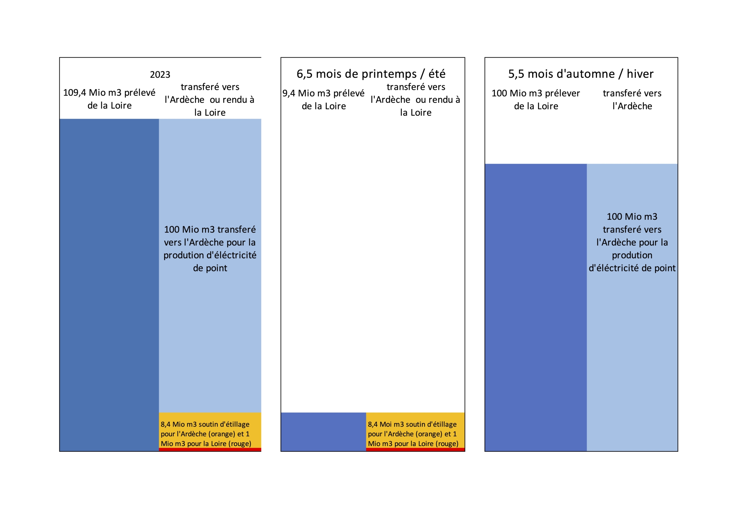
Volumes stored and transferred to the Ardèche or returned to the Loire
In 2023, 108.4 million m3 were transferred to the Ardèche (compared with 220 million m3 in the “best” years). Most of this, 100 Mio m3, was taken from the Loire in autumn and transferred in winter for peak electricity production. The significant drop in rainfall in autumn/winter resulted in a 50% reduction in winter turbines compared with the past.
In spring, 9.4 Moi m3 were stored in the reservoirs on the Loire side and used to support the low-water levels of the Ardèche (8.4 Moi m3) and the Loire (1 Moi m3), in line with the low-water support objectives. The year 2023 had got off to a bad start, however, and it seemed impossible to fill the reservoirs at the La Palisse, Gage and Issarlès dams, but the weather came to the complex’s rescue in the last few weeks, just before the summer period, which means that the Issarlès lake must remain open to tourists.
Volumes stored and transferred to the Ardèche or returned to the Loire in 2023
Features of the developments
Lake Issarlès: a natural crater reservoir
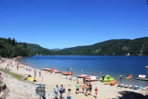
Lake Issarlès is a natural lake located at an elevation of 1000 metres. It is 138 metres deep, covers an area of 90 hectares and has a useful storage capacity of 30 million cubic metres. It is used as a transitional reservoir prior to turbine operation outside the summer season. Water is directed into the lake and then sent back to Montpezat through a conduit located 50 metres below the surface. In the summer, a “natural water level” is maintained; otherwise, hydroelectric production causes significant fluctuations in the lake’s water level.
> The water intake of the Grange on the Veyradeyre
This dam is not used for reservoir but supplies a water intake that feeds Lake Issarlès. Standing 12.5 metres high and 45 metres long, it has a useful storage capacity of 0.05 million cubic metres for a surface area of 0.48 hectares. It was commissioned in 1954.
.
> The Lapalisse dam
The Lapalisse dam is located directly on the Loire and is the largest structure in the entire complex. Its watershed covers an area of 130 square kilometres. Standing 55.8 metres high and 195 metres long, it has a useful capacity of 7.5 million cubic metres for a total surface area of 46.8 hectares. Like the other structures, it was commissioned in 1954 and was upgraded in 2019 to withstand a millennial flood.
The Gage dam is located on two right-bank tributaries of the Loire: the Tauron and the Gage. Standing 39.6 metres high and 156 metres long, it has a useful storage capacity of 3.3 million cubic metres for a surface area of 32.4 hectares. Filling began in 1954. Since 2018, it has been equipped with a new floodgate capable of handling millennial floods.
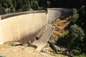
Barrage du Gage
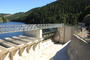
Evacuateur de crue du barrage du Gage
Montpezat powerplant
The Montpezat power plant is carved directly into the Ardèche mountainside at a depth of 120 metres. The penstock extends over 636 metres. The average turbine flow rate is 7 cubic metres
per second, and it can reach a maximum of 24 cubic metres per second during peak demand, producing 290 gigawatt hours of electricity each year. After passing through the turbines, the water is released into the Pont de Veyrère Dam (on the Fontaulière River) through a 2.6-kilometre underground gallery.
The Pont-de-Veyrières dam
The Pont de Veyrières dam is located downstream of the complex on the Fontaulière, a tributary of the Ardèche. It stands 35 metres high and was commissioned in 1985. This dam serves as a demodulation structure for the releases from the Montpezat plant, smoothing out the flow downstream.